Jual GPS Magellan Explorist 510
Perhatian!
Spesifikasi Jual GPS Magellan Explorist 510
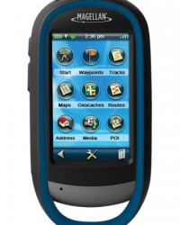
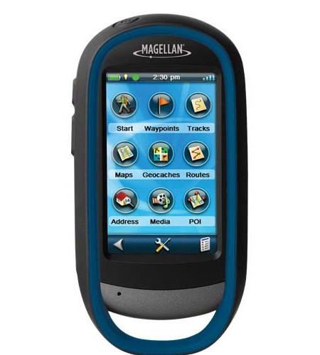
GPS Magellan eXplorist 510
Premium, rugged, handheld GPS unit with 3.2 megapixel camera, microphone, and speaker to record all your actions and optional topographic maps for safe outdoor navigation.
3.2 mega-pixel Camera with Auto Focus
‘World Edition’ Premium Basemap Preloaded
3 Inch Touch Screen
Create waypoints, record tracks, route from point to point
Rugged and waterproof (IPX-7 standards), the eXplorist 510 combines high sensitivity GPS reception with easy to read mapping and accurate navigation. Find your way using more than 30 navigational data fields. Create waypoints, record tracks, and route from point to point.
The integrated 3.2 mega-pixel camera, microphone, and speaker enables you to record geo-referenced images and voice notes. Relive and share your outdoor adventures.
The Magellan eXplorist 510 comes preloaded with the World Edition map allowing 2D or 3D viewing angles. It includes a complete road network in Australia, United States, Canada and Western Europe and major roads throughout the rest of the world. The eXplorist 510 has a micro SD card slot. This means you can access the following maps as an optional download via SD card – The GeoScience Australia 1:250k Raster Map, Summit Series Australia/New Zealand Topographic Map and the City Series Australia/New Zealand routable Tourer Map for the ultimate in outdoor navigation.
The eXplorist 510 navigation system combines the user friendliness of a touch screen with the reliability of two customisable hard buttons and the one touch favourites menu system giving you total control. Powered by two AA batteries (a pair of AA lithium batteries are supplied in the box with the unit), the eXplorist 510 will last up to 16 hours under normal conditions.
The eXplorist 510 offers paperless Geocaching. Download and view more than 20 unique characteristics of each cache, giving you seamless access to 21st Century treasure hunting.
The eXplorist 510. An easy to use touchscreen GPS receiver with core navigation at your fingertips.
Core Outdoor Navigation
Rugged and waterproof, with high sensitivity GPS reception and more than 30 navigational data fields. Create waypoints, record tracks, and route from point to point with backtrack feature for extra safety.
Experience Recording
Integrated 3.2 mega-pixel camera, microphone, and speaker enables you to record geo-referenced images and voice notes and relive or share your adventures.
Superior Maps with 3D Perspective View
The World Edition map allows for 2D or 3D viewing angles and covers the globe with details, roads and land use areas. You also have the option to download via SD the GeoScience Australia 1:250k Raster Map, the Summit Series Australia/New Zealand Topographic Map and the City Series Australia/New Zealand routable Tourer Map.
3.0
Combining the user friendliness of a touch screen with the reliability of two customisable hard buttons. Program the hard buttons to your two favourite or most used functions.
Paperless Geocaching
Download and view more than 20 unique characteristics of each cache and view, search, filter on the device.
16 Hours of Battery Life
Powered by two AA batteries, the eXplorist will last up to 16 hours under normal conditions. To help conserve power, use the suspend mode to turn off the device but maintain GPS tracking.
OneTouch Menu
Magellan’s award winning OneTouch(TM) favourites menu provides instant access to bookmarks of favourite places or actions. 12 customisable icons to create personalised searches, save unique locations, or assign quick access to your favourite screens. Giving you total control.
World Edition Premium Basemap Pre-loaded
The World Edition includes a complete road network in Australia, United States, Canada and Western Europe and major roads throughout the rest of the world that provides cartographic orientation in almost any location. This unique preloaded map also includes water features, urban and rural land use, and a realistic shaded relief background.
Area Calculation
A great tool to work out land area or property size. Set an active track, walk the perimeter of the track ensuring you return to your starting point and your eXplorist will calculate the area in square meters or square feet.
DEVICE
Dimensions 65.3mm x 128mm x 36.8mm
Weight 195g
Screen 3.0
Display Resolution WQVGA, 240 x 400
Mitra Laser Survey
Dengan bermacam macam merk terkenal seperti :
* Total Station | Digital Theodolite | Automatic Level
Topcon, Nikon, Sokkia, Pentax, South, Leica, Sincon, Neolaser, Mysurv, CST Berger, Kolida, Minds
* GPS ( Global Positioning System )
Garmin, Trimble, Topcon, South, Spectra, Magellan
* Laser Meter / Meteran Laser
Neolaser, Line, Leica, Precaster, Bosch, Agatec, Robotoolz
* Kompas | Clinometer | Altimeter
Suunto, Brunton, Silva, Freiberg
* Teropong / Binoculars
Steiner, Hunter, Nikon, Bushnell, Celestron.
* HT / Handie Talkie | Radio Repeater
Motorola, Icom, Yaesu, Alinco, Suicom, Kenwood, SMP, Weierwei, Firscom
* Lainnya
Inmarsat, Ericson, Isatpone, Aces, Estwing, Lutron, Eutech, Mastech, Tajima Slant, dll.
METODE PEMBAYARAN :
Pembayaran dapat dilakukan dengan cara Cash On Delivery / Transfer Bank.
* C.O.D. ( Cash On Delivery / Bayar ditempat)
Khusus nuntuk wilayah Jakarta kami melayani pemesanan dengan cara pembayaran di tempat anda, Prosesnya :
1. Pesanan anda kami antar ke tempat anda
2. Setelah anda terima silahkan cek kelengkapan dan kualitas barang
3. Bila sudah ' OK' dan tidak ada masalah baru dibayar
Pembayaran ditempat bisa dalam bentuk tunai ataupun Transfer .
Transfer Bank
Pembayaran dapat dilakukan dengan Transfer Bank, baik melalui ATM, Setoran Tunai, Internet banking atau mobile banking. Berikut ini informasi Account bank yang kami gunakan:
BANK BCA
No.Rekening : 321 039 2997
Atas Nama : Rian Hadianto
BANK MANDIRI
No.rekening : 131 00100 58958
Atas Nama : Rian Hadianto
BANK BNI
No.rekening : 0333-6699-61
Atas Nama : Rian Hadianto
BANK BRI
No.rekening : 0100-01-062531-50-4
Atas Nama : Rian Hadianto
Untuk info dan harga terbaik, silahkan hubungi :
Mr.Rifky Faisal Bahri
Phone : 085353410506 / 089618877628 / 082216069899
Email : rifkifaisal93@ gmail.com / rifky.gps93@ gmail.com
Fax : 021-29040157


