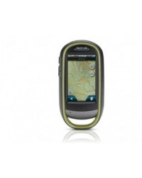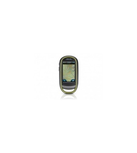
GPS Magellan eXplorist 610
Perhatian!
Spesifikasi GPS Magellan eXplorist 610
GPS Magellan eXplorist 610
Product description : Premium, rugged, handheld GPS system with 3.2 megapixel camera, 3-Axis Compass, Barometric Altimeter, and topographic maps to record all your movements and navigate the outdoors with accuracy and safety.
- Summit Series Australia and New Zealand topographic map built in
- Touch Screen with 2 customisable hard buttons
- 3-Axis Electronic Compass
- Barometric Altimeter
- 3.2 mega-pixel Camera with Auto Focus
Rugged and waterproof (IPX-7 standards), the eXplorist 610 combines high sensitivity GPS reception with easy to read mapping and accurate navigation. Find your way using more than 30 navigational data fields. Create waypoints, record tracks, and route from point to point.
The Magellan eXplorist 610 comes with a 3-Axis Compass and Barometric Altimeter for superior navigation and guidance. And unique to the eXplorist series, the 3-Axis Compass can be calibrated whilst on the move.
The integrated 3.2 mega-pixel camera, microphone, and speaker enables you to record geo-referenced images and voice notes. Relive and share your outdoor adventures.
The eXplorist 610 navigation system packs the most accurate maps into the palm of your hand. The World Edition map allows for 2D or 3D viewing angles. It includes a complete road network in Australia, United States, Canada and Western Europe and major roads throughout the rest of the world. The eXplorist 610 also includes the Summit Series Australia/New Zealand Topographic Map. These maps in combination provide water features, urban and rural land use, contour lines, trails, waterways and points of interest. In addition the eXplorist 610 gps system gives you the option to download the City Series Australia / New Zealand Tourer Map with turn by turn street navigations. The eXplorist 610 also comes preloaded with the GeoScience Australia 1:250k Raster Map giving you the most superior map coverage for your outdoor adventures.
The eXplorist 610 combines the user friendliness of a touch screen with the reliability of two customisable hard buttons and the one touch favourites menu system giving you total control. Powered by two AA batteries (a pair of AA lithium batteries are supplied in the box with the unit), the eXplorist 610 will last up to 16 hours under normal conditions.
The eXplorist 610. Superior navigation for confidence in the great outdoors.
Core Outdoor Navigation
Rugged and waterproof, with high sensitivity GPS reception and more than 30 navigational data fields. Create waypoints, record tracks, and route from point to point with backtrack feature for extra safety.
Experience Recording
Integrated 3.2 mega-pixel camera, microphone, and speaker enables you to record geo-referenced images and voice notes and relive or share your adventures.
Superior Maps with 3D Perspective View
The World Edition map allows for 2D or 3D viewing angles and covers the globe with details, roads and land use areas. It also includes the Summit Series Australia Tourer Map including routable topographic map and turn by turn street navigation as well as the GeoScience Australia 1:250k Raster Map.
3.0
Combines the user friendliness of a touch screen with the reliability of two customisable hard buttons. Program the hard buttons to your two favourite or most used functions.
3-axis Electronic Compass & Barometric Altimeter*
Always know exactly where you are going, which direction is north, and your accurate altitude above sea level with built-in sensors. Measure barometric pressure over time to track changing weather conditions.
Paperless Geocaching
Download and view more than 20 unique characteristics of each cache and view, search, filter on the device.
16 Hours of Battery Life
Powered by two AA batteries, the eXplorist will last up to 16 hours under normal conditions. To help conserve power, use the suspend mode to turn off the device, while maintaining GPS tracking.
OneTouch; Menu
Magellan’s award winning OneTouch(TM) favourites menu provides instant access to bookmarks of favourite places or actions. 12 customisable icons to create personalised searches, save unique locations, or assign quick access to your favourite screens, giving you total control.
World Edition Premium Basemap Pre-loaded
The World Edition includes a complete road network in Australia, New Zealand, United States, Canada and Western Europe and major roads throughout the rest of the world that provides cartographic orientation in almost any location. This unique preloaded map also includes water features, urban and rural land use, and a realistic shaded relief background.
Summit Series Australia/New Zealand Topographic Map
As well as the GeoScience Australia 1:250k Raster Map giving you contour lines, land use areas, trails, waterways and points of interest for superior map coverage for all your outdoor activities or adventures.
DEVICE |
|
| Dimensions | 65.3mm x 128mm x 36.8mm |
| Weight | 195g |
| Screen | 3.0 |
| Display Resolution | WQVGA, 240 x 400 |
Mitra Geologi
