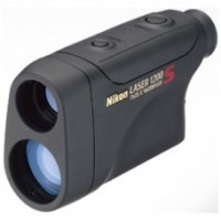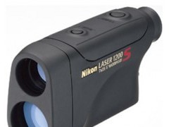
Laser Rangefinders Nikon Laser 1200S

Update Terakhir
24-08-2013
Minimum Pembelian
1 unit
Dilihat Sebanyak
305 kali
Lokasi
Harga
Rp. 4.950.000
Bagikan
+ Penawaran

Spesifikasi Laser Rangefinders Nikon Laser 1200S

 Description

Measurement range: 10-1,100m/11-1,200 yd.
Target Priority Switch System for measuring overlapping subjects:
First Target Priority mode displays the distance of the closest subject – useful when measuring the distance to a subject in front of an overlapping background.

  • Distant Target Priority mode displays that of the farthest subject – useful in wooded areas.
  • High-quality 7x monocular with multilayer coating for bright, clear images
  • Long eye relief design affords eyeglass wearers easy viewing
  • Dioptre adjustment function
  • Single or continuous measurement (up to 20 seconds)
  • Easy one-push measurement after the power is turned on
  • Compact, lightweight design enables easy, single-hand operation
  • LCD with backlight
  • Waterproof (up to 2m/6.6 ft. for 5 minutes), but not for underwater usage; the battery chamber is water-resistant
  • Wide temperature tolerance: -10ºC to +50ºC

 Specifications

  Laser 1200S
Measurement range 10-1,100m (11-1,200 yd.)
Distance display (Increment) Every 0.5m/yd. (shorter than 1,000m/yd.)
Every 1m/yd. (1,000m/yd. and over)
Finder Magnification (x) 7
Effective objective diameter (mm) 25
Actual field of view (º) 5.0
Exit pupil (mm) 3.6
Eye relief (mm) 18.6
Dimensions (LxHxW) (mm) 145x82x47
Weight (g) (excluding battery) 280
Power source CR2 lithium battery x 1 (DC3V)
Auto power shutoff function equipped (after 8 sec.)
Safety Class 1M Laser Product (EN/IEC60825-1:2007)
EMC FCC Part15 SubPartB class B, EU:EMC directive, AS/NZS, VCCI class B
Environment RoHS, WEEE
Tampilkan Lebih Banyak

Gis glonal

 About Us
GIS GLOBAL is an e-commerce or online shopping tools required in the various fields of GPS equipment, survey equipment (Surveying Instruments) with various types of equipment such as: Total Station, Digital Theodolite, Automatic Level / Waterpass, Compass, Altimeter, Clinometer, Distometer and Geological Survey Tools, Safety Tools insudtry, Satellit Radio Communications and Devices, Mining, forestry and Construction Projects and Equipment.
 
With Human Resources experience and reliable, we provide pelayaan appropriate, we also developed a Training Services business unit / GPS applications and Training Survey. Because of the experience we are committed to providing the best solutions in the application of the product and service to all the partners that can provide great benefit in improving the quality and the ability to run a business and its business.
 
VISION
 
Grow in harmony, Reliable and trusted in innovation, distribution, and localization of parts in both treatment programs and Equipment GPS Survey. And support in good times and fast delivery, and to provide quality and professional solutions to any business partner.
 
MISSION
 
Become efficient and effective, and grow continuously improve service quality excellence in order to achieve customer satisfaction. Determination to achieve the vision and mission management team and all GIS GLOBAL is always trying to make improvements, renewal and learning of knowledge and Surveying GPS technology, ranging from infrastructure, services and human resources. In order to be a reliable partner both in enterprise-scale regional, national and international.


Company Name: GLOBAL PT.GIS
TIN/NPWP : 03.042.405.5-035.000

Jl.Pejuangan Mawar III No.15.A
Kebon Jeruk Jakarta Barat 11350
Phone: +6221 71399316 ,53670757
Fax :+6221 53670757
Email : info@geosurveying.net

 
Tampilkan Lebih Banyak
Free Member
 
Jl.Pejuangan Mawar III.15A Kebon Jeruk jakarta barat
Login Terakhir 11-04-2017
085286472852
081291666578

Produk Lainnya


CALL
PT. Petirindo Jaya Abadi
CALL
PT. Petirindo Jaya Abadi
CALL
PT. Petirindo Jaya Abadi
CALL
PT. Petirindo Jaya Abadi
CALL
PT. JE Indonesia ( Distributor & Service )
CALL
PT. JE Indonesia ( Distributor & Service )