Furuno GP 7000
Update Terakhir
05-04-2013
Dilihat Sebanyak
373 kali
Lokasi
Harga
Kontak Kami
Bagikan
+ Penawaran
Perhatian!
Perusahaan ini terdaftar sebagai Free Member. Hindari melakukan pembayaran sebelum bertemu penjual atau melihat barang secara langsung. COD (Cash On Delivery) atau bertemu langsung dengan penjual merupakan metode transaksi lebih aman.
Spesifikasi Furuno GP 7000
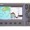
The GP-7000/ NT is a GPS/ WAAS plotter designed for a variety of vessels desiring video plotting capabilities. With the GP-7000 series, you can see the highly accurate position of your boat on the chart.
The GP-7000 series has four display modes: Course Plot, Nav Data, Steering, and Highway modes. The course plot mode is useful for obtaining general information about surrounding sea areas. The Nav data mode clearly shows important navigational information with large text, which is easy to see even from a distance. The steering mode and highway mode assist the operator in following a predetermined route.
The GP-7000 series uses C-Map NT+ charts. These charts provide navigational information including water depth, contours, coastlines, lighthouses, buoys, etc. The use of the SD cards facilitates the management of the expanded chart data.
GP7000/ NT Specifications:
High-performance GPS/ WAAS receiver
Sunlight viewable 7" TFT bright color LCD ( wide 16: 9 aspect ratio)
Compatible with C-Map NT+ chart cards
Dual SD card slots for memory and chart cards ( Conventional SD cards can be used for waypoint/ route backup. Please note that previously available FP cards ARE NOT USED with the GP-7000 Series)
Enhanced chart redraw speed
Display modes: Course Plot, Nav Data, Steering, Highway
User-friendly interface and operation with rotary encoder and soft keys
Power Requirements:
12-24 VDC, 1.5-0.8 Amps
Marine Maju Mandiri
Kami adalah general supplier dalam bidang marine.
Perusahaan kami dapat menyediakan semua kebutuhan dalam bidang marine secara teknikal maupun safety nya.
Dengan bermotto harga kompetitif dan menjaga kepercayaan pelanggan, kami berharap dapat menjalin kerjasama dengan Anda.
Perusahaan kami dapat menyediakan semua kebutuhan dalam bidang marine secara teknikal maupun safety nya.
Dengan bermotto harga kompetitif dan menjaga kepercayaan pelanggan, kami berharap dapat menjalin kerjasama dengan Anda.
Marine Maju Mandiri
Free Member
Lindeteves Trade Center Glodok Lt 1 Blok B 16 No 2-3 Jakarta Barat 11180, Jakarta Indonesia
Login Terakhir 05-04-2013
02135992088
08129953560
Produk Lainnya

