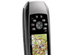
Garmin Gpsmap 78s
Perhatian!
Spesifikasi Garmin Gpsmap 78s
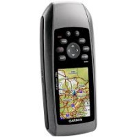
Garmin GPSMap 78s
GPSMAP 78s: Colorful maps, durable design and buoyant – everything a mariner needs.
Physical & Performance: |
|
|
Unit dimensions, WxHxD: |
2.6" x 6.0" x 1.2" (6.6 x 15.2 x 3.0 cm) |
|
Display size, WxH: |
1.6" x 2.2" (4.1 x 5.6 cm); 2.6" diag (6.6 cm) |
|
Display resolution, WxH: |
160 x 240 pixels |
|
Display type: |
transflective, 65-K color TFT |
|
Weight: |
7.7 oz (218.3 g) with batteries |
|
Battery: |
2 AA batteries (not included); NiMH or Lithium recommended |
|
Battery life: |
20 hours |
|
Waterproof: |
yes (IPX7) |
|
Floats: |
yes |
|
High-sensitivity receiver: |
yes |
|
Interface: |
high-speed USB and NMEA 0183 compatible |
Maps & Memory: |
|
|
Basemap: |
yes |
|
Ability to add maps: |
yes |
|
Built-in memory: |
1.7 GB |
|
Accepts data cards: |
microSD™ card (not included) |
|
Waypoints/favorites/locations: |
2000 |
|
Routes: |
200 |
|
Track log: |
10,000 points, 200 saved tracks |
Features: |
|
|
Automatic routing (turn by turn routing on roads): |
yes (with optional mapping for detailed roads) |
|
Electronic compass: |
yes (tilt-compensated, 3-axis) |
|
Touchscreen: |
no |
|
Barometric altimeter: |
yes |
|
Camera: |
no |
|
Geocaching-friendly: |
yes (paperless) |
|
Custom maps compatible: |
yes |
|
Photo navigation (navigate to geotagged photos): |
yes |
|
Outdoor GPS games: |
no |
|
Hunt/fish calendar: |
yes |
|
Sun and moon information: |
yes |
|
Tide tables: |
yes |
|
Area calculation: |
yes |
|
Custom POIs (ability to add additional points of interest): |
yes |
|
Unit-to-unit transfer (shares data wirelessly with similar units): |
yes |
|
Picture viewer: |
no |
|
Garmin Connect™ compatible (online community where you analyze, categorize and share data): |
yes |
What's in the Box:
- GPSMAP 78s
- Wrist strap
- USB cable
- Quick start manual
dirta jaya survey
DIRTA JAYA SURVEY
adalah penjualan, alat survey. Kami disini sebagai supplier alat survey tanah atau bangunan, alat survey telekomunikasi, alat survey geologi atau mining, dan alat survey lainnya diantaranya Total Station, Digital Theodolite, Automatic Level, GPS, Kompas, Binoculars, Monocullars, Laser Rangefinder, Teropong Malam, Digital Altimeter, Clinometer, Tandem, Digital Planimeter, Distometer Speed Gun, Measuring Wheel, Measuring Tape, Grounding Tester, HT Handy Talky, Sound Level Meter, dan alat alat Geologi. Ditunjang dengan merk merk yang sudah terkenal dan telah diakui keberadaanya didunia survey diantaranya Topcon, Nikon, Sokkia, Garmin, Trimble, Magellan, Suunto, Horizon, Bushnell, Brunton , Leica, Bosch, South, Yamayo, Tajima, Icom, Kyoritsu, dll. Semoga keberadan kami dapat menjawab sekaligus memenuhi kebutuhan alat survey yang keberadaannya sangat dibutuhkan pada era perkembangan pembangunan dan tekhnologi pada saat ini
