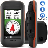
GARMIN Montana 650 GPS
Perhatian!
Spesifikasi GARMIN Montana 650 GPS
View the great outdoors in widescreen with Montana. This incredible handheld has a luxurious 4" touchscreen, a massive 3GB memory and a 5 megapixel autofocus camera. Ideal for long expeditions in-car or on the trail, a lithium-ion battery pack gives a combined 22 hours usage.
The Montana 650 is the all-encompassing giant of the Garmin range. With the rugged outdoor features we've come to expect from these expertly designed handhelds (barometric altimeter, 3-axis compass, Hotfix® receiver) the 650 also has a sleek 5 megapixel autofocus camera. This adds a new level of sophistication to geocaching hunts by automatically geotagging the location of your images, with a massive 3GB memory for storing endless shots, routes and waypoints. Aside from the huge 4" touchscreen for incredibly detailed map viewing, a lithium-ion battery pack allows the possibility of a whopping 22 hours use when combined with the AAs, making it the ideal choice for long trips and professional expeditions. Extremely rugged, and able to withstand sand, mud, dust and snow, a glove friendly touchscreen means that even in extreme cold you have the most reliable GPS technology in the world at your fingertips.
· 5 megapixel camera - with autofocus for detailed images that are automatically geotagged for location.
· 4" sunlight readable transflective colour touchscreen - scroll through maps easily in incredibly bright detail, with dual orientation.
· Supports paperless geocaching - just upload the GPX file from OpenCaching.com and start your hunt.
· Barometric altimeter - uses air pressure to give you detailed altitude readings which is crucial for accuracy on steep inclines.
· 3-axis tilt compensated compass - no need to hold it steady for accurate readings.
· WAAS-enabled HotFix® technology with quad helix antenna - unrivalled accuracy will keep track of you even under deep cover.
· Rugged waterproof casing (IPX7) - will withstand rain, dust, dirt and mud.
· BirdsEye Satellite Imagery™ (subscription required) - download satellite images to integrate with your maps.
· Share using Garmin Connect™ - a fantastic online forum with millions of users worldwide.
· Connects with Garmin Basecamp™ - plan your routes, tracks and waypoints before you head out.
· Worldwide base map - gives you OS grid or lat/long references with shaded relief for elevation.
· 3GB on-board memory & microSD™ slot - room for 4000 waypoints with the option of storing huge areas of added maps such as City Navigator.
· Lithium-ion rechargeable battery pack - gives you 16 hours of use or combined with the AA batteries 22.
· Custom mapping - convert old paper maps into electronic files to use with your device.
· Recommended activity - walking / geocaching / off-roading
Digital Instrument
Selamat Datang Di
Digital Instrument - Industrial Equipment Online Store
Industrial Equipment - Menjual Berbagai Macam Peralatan Kebutuhan Industri Seperti :
Surveying : Total Station, Digital Theodolite, Automatic Level / Waterpass, Hand Level, Measuring Tape, Measuing Wheel, Laser Distance Meter, Range Finder.
Geology Tools : Compass, Clinometer, Rain Gauge, Altimeter, Palu, Current Meter.
Global Positioning System ( GPS) : Navigation, Aviation, Marine, Sport, Handheld, Geodetic dan Mapping.
Electrical Test Tool : Clamp Meter, Multimeter, pH Meter, Vibration Meter, Sound Level Meter, Light Meter, Thermometer, Anemometer, Tachometer, Oscilloscope, Spectrum Analyzer, Power Supply, Frequency Counter, Function Generator, Audio Generator, Signal Generator.
Communication : Handy-Talkie, Repeater, Satelite Phone.
Teropong : Binocular, Monocular, Telescope, Microscope.
