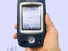
Jual Astech Mobile Mapper 10
Perhatian!
Spesifikasi Jual Astech Mobile Mapper 10
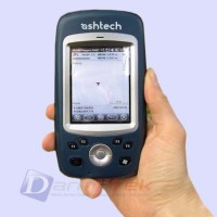
Today with MobileMapper 10, Ashtech makes it possible to massively deploy a professional accurate GIS receiver to any field work force.
Boost Your Mapping Productivity with MobileMapper 10
- Log your assets in real-time with meter accuracy
- Connect field and office work force for maximum proactivity
- Reach sub-half meter accuracy with post-processing
Unpack and Start Logging with MobileMapper 10
- Ready to use complete mapping solution for field and office
- User friendly Windows® Mobile 6.5
- Easy-to-use software for short learning curve and quick logging operations
Made For Mobile GIS Work Force
Compact & lightweight design for optimal mobility, use and comfort
Integrated communications for easy data transfer
Only receiver offering several days of battery life
Ruggedized for outdoor use
MobileMapper Field and Office Software: a complete solution
The Ashetch MobileMapper software suite includes all GIS features that professionals really need without the burden of complicated and rarely used functions, both on field and office sides.
Running on MobileMapper receivers, MobileMapper Field is the perfect solution for GIS data collection, asset management, area measurements, maps creation and updates. The software is very intuitive and easy to use, requiring minimum training. It also provides direct interface to external sensors for a complete solution.
The Ashtech MobileMapper Office tool can be used to differentially post process raw GPS data collected with the MobileMapper Field software. Through an Internet connection, MobileMapper Office can automatically find and download the base data files that will match the collected raw data; it will compute corrected positions automatically.
Tune MobileMapper 10 with your Applications
With Windows Mobile 6.5 you may upload necessary utilities or software on your MobileMapper 10, to suit your next job. You can collect GIS/GPS points and maps via the GIS application of your choice, either a third party software such as ESRI ArcPad or the proprietary Ashtech application.
DarmatekInstrument
DARMATEK berasal dari sebuah Toko yang berdiri sekitar tahun 2010 yang bergerak di bidang alat-alat safety, teknik dan elektronik.
Karena seiring dengan waktu dan perkembangan yang begitu pesat maka kami mencoba untuk memasarkan secara online berbagai Produk dan Merk di bidang Safety, Teknik, Electronic, Survey, Sirene, Laboratory, dLL. Tujuannya agar market kami dapat menjangkau seluruh wilayah Indonesia.
Toko online kami berkomitmen mengedepankan Pelayanan yang maksimal dengan melakukan efisiensi waktu, dan biaya, sehingga para konsumen tidak perlu lagi " memusingkan diri " dalam pemesanan barang. Anda pesan, harga deal, kami antar barang anda.
Kami juga menyediakan alat alat untuk keperluan Survey dan Laboratorium seperti: Total Station, Auto Level, Theodolite, Lasermeter pengukur Jarak, Teropong/ Binocullar, Nightvision, Kompas, Altimeter, Anemometer, Weather Station, Lux Meter, Thermometer Hygrometer dst dengan ditunjang merek-merek yang sudah terkenal di dunia survey seperti : TOPCON, SOKKIA, NIKON, SOUTH, HORIZON, LEICA, GARMIN, SUUNTO, BRUNTON, LUTRON, SMART SENSOR, DAVIS, LUTRON, SANFIX, PCE, SANWA, TENMARS, PCE, SEW, PROTEK, AZ INSTRUMENT, SIRINE, ATTEN, OWON, DEKKO, AMPROBE, ATAGO dan lain-lain.
Darmatek terus berupaya melakukan perbaikan dan penyempurnaan diri sebagai Wujud Partisipasi aktif untuk memajukan Industri di berbagai bidang di Indonesia dengan “ Kwalitas dan Harga terbaik”
