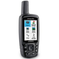
Garmin GPSMap 62SC
Perhatian!
Spesifikasi Garmin GPSMap 62SC
Features Garmin GPSMap 62SC:
• 2.6" sunlight-readable color screen
• 5 MP autofocus camera with automatic geotagging
• Built-in worldwide basemap with shaded relief
• High sensitivity quad helix GPS antenna for unparalleled reception
• 3-axis compass with barometric altimeter
GPSMAP 62sc handheld navigator features a 3-axis tilt-compensated compass, a barometric altimeter, a 5 megapixel autofocus camera with photo navigation, and support for Custom Maps and BirdsEye Satellite imagery (subscription required). Rugged and waterproof, GPSMAP 62sc employs a quad helix antenna for unparalleled reception, has a high-speed USB connection and connects wirelessly to compatible handheld devices.
GPSMAP 62sc has a built-in 3-axis tilt-compensated electronic compass, which shows your heading even when you’re standing still, without holding it level. Its barometric altimeter tracks changes in pressure to pinpoint your precise altitude, and you can even use it to plot barometric pressure over time, which can help you keep an eye on changing weather conditions.
Specifications for the GPSMap 62SC:
|
Physical & Performance |
|
|
Physical dimensions |
2.4" x 6.3" x 1.4" (6.1 x 16.0 x 3.6 cm) |
|
Display size, WxH |
1.43" x 2.15" (3.6 x 5.5 cm); 2.6" diag (6.6 cm) |
|
Display resolution, WxH |
160 x 240 pixels |
|
Display type |
transflective, 65-K color TFT |
|
Weight |
7.9 oz (223 g) with batteries |
|
Battery |
2 AA NiMH batteries (included) |
|
Battery life |
16 hours (2 AA batteries) |
|
Water rating |
IPX7 |
|
High-sensitivity receiver |
✓ |
|
Interface |
high-speed USB and NMEA 0183 compatible |
|
Camera |
yes (5 megapixel with autofocus; automatic geo-tagging) |
|
Barometric altimeter |
✓ |
|
Electronic compass |
Yes (tilt-compensated 3-axis) |
|
Unit-to-unit transfer (shares data wirelessly with similar units) |
✓ |
|
Maps & Memory |
|
|
Basemap |
✓ |
|
Ability to add maps |
✓ |
|
Built-in memory |
3.5 GB |
|
Accepts data cards |
microSD™ card (not included) |
|
Custom POIs (ability to add additional points of interest) |
✓ |
|
Waypoints/favorites/locations |
2000 |
|
Routes |
200 |
|
Track log |
10,000 points, 200 saved tracks |
|
Outdoor Features |
|
|
Automatic routing (turn by turn routing on roads) |
Yes (with optional mapping for detailed roads) |
|
Geocaching-friendly |
Yes (Paperless) |
|
Custom maps compatible |
✓ |
|
Hunt/fish calendar |
✓ |
|
Sun and moon information |
✓ |
|
Tide tables |
Yes (with optional Bluechart) |
|
Area calculation |
✓ |
|
Picture viewer |
✓ |
|
Garmin Connect® |
|
|
Garmin Connect™ compatible (online community where you analyze, categorize and share data) |
✓ |
Package includes:
• GPSMAP 62SC
• Carabiner clip
• USB cable
• Quick start manual
CV. MULTIARYA
Kami hadir membawa berbagai kemudahan dan keuntungan bagi bisnis Anda.
Sejarah berdirinya
MULTIARYA berdiri sejak tahun 2009, dan baru diresmikan pada tanggal 18 November 2010. Kami adalah Authorized Dealer resmi dari Alat-alat Survey, Alat Geologi, Alat Komunikasi, dan Alat Telekomunikasi. Kami hanya menjual brand-brand yang terkenal dibidang masing-masing dan dapat terjamin keasliannya. Multiarya bertempat di daerah Jakarta Selatan, kami memilih daerah tersebut dikarenakan akses yang memudahkan para pelanggan untuk mengunjungi kantor kami.
Visi dan Misi
VISI: Menjadi perusahaan yang baik dan terpercaya bagi pelanggan - pelanggan serta meningkatkan kesejahteraan melalui tanggung jawab sosial dan kepedulian lingkungan.
MISI: Menjamin adanya pelayanan optimal yang dapat diandalkan memprioritaskan kepuasan menjalin hubungan kerja yang baik dan saling menguntungkan kualitas dan kuantitas yang terjamin.


